
If you find errors OR have additional information about this site, please send a message to contact@waynehistorians.org.
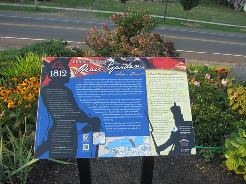
War of 1812 Peace Garden Interpretive Panel
| Historic Site #: | 12-140 (Exists) Type: B4 | Town: | Sodus | ||
| Site Name: | War of 1812 Peace Garden Interpretive Panel | GPS Coordinates: | 43.27024, -76.98295 | ||
| Address: | 8440 Bay Street Sodus Point New York on the south side of the road in the 1812 Peace Garden | ||||
| Description: | |||||
| War of 1812 Peace Garden Interpretive Panel in Sodus Point | |||||
| 🔊Audio: Tour Sound Bite |
 |
| Photo courtesy of Edith Farrington |
| Historic narrative: | |||||
The battle of Troupesville (later renamed Sodus Point) was fought at the brow of this hill on the rainy evening of June 19th, 1813. A group of approximately 60 Americans (farmers with no military training and poorly trained militia) fired into a group of about 200 British marines as they ascended the hill. Two Americans (Asher Warner and Charles Terry) and three British soldiers would die from wounds received. After the initial volley, the Americans retreated into the underbrush and the British retreated back to the five ships that lay in anchor offshore. Three Americans were captured as the two sides intermingled in the darkness but they were released the next day.
The following day, the British ships fired cannons into the village and once more landed. The British took supplies from the local warehouse. The Americans expecting this, had taken most of the supplies from the warehouse and hidden them in a nearby ravine. Afterward, the British troops burned all the public buildings except the Mansion House where a mortally wounded Asher Warner had been moved to by British soldiers. It is said that the British placed a pitcher of water near him and that the officers twice extinguished a fire kindled by the men to destroy the building.
This memorial is to honor the brave men who lost their lives during the battle and the lasting peace between the two nations that has endured ever since the War of 1812. | |||||
Historic Sodus Point web page