
If you find errors OR have additional information about this site, please send a message to contact@waynehistorians.org.
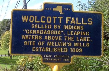
Wolcott Falls Historic Marker
| Historic Site #: | 15-004 (Exists) Type: B2,M | Town: | Wolcott | ||
| Site Name: | Wolcott Falls Historic Marker | GPS Coordinates: | 43.221485, -76.811368 | ||
| Address: | 12067 Mill St. Wolcott NY | ||||
| Description: | |||||
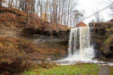
| Located in the Village of Wolcott on Mill Street (Ridge Road), Wolcott Falls - named Ganadasgua Falls by the Haudenosaunee - is a picturesque trail and view - a favorite on many local photographers. Wolcott Creek flows north six miles from the Town of Butler near Tamarack Swamp to the Mill Pond in the Village of Wolcott. The Mill Pond is located on the south side of Mill Street. The creek crosses under Mill Street and then the creek falls drop fifty feet over shale to a nice pool and ledge at the bottom. The creek then continues north to its outlet in Port Bay and on to Lake Ontario. The overall journey of Wolcott Creek is around 15 miles. | |||||
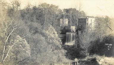 | |
| Wolcott Falls YouTube Video | Post Card circa 1910 - courtesy Steve Heald |
 |
 |
| Lizzie Fox 2021 |
| Historic narrative: | |||||
Celebrating Native American Heritage Long before Wolcott was settled, a wilderness of trees and swamps hosted all manner of wildlife including deer, bear, wolves, many varieties of fish, as well as berries, herbs, and plenty of trees, including willow. The splendor of Ganadasgua Falls is a well-hidden beauty in the Village of Wolcott. The Haudenausaunee (Iroquois) word Ganadasgua translates to “leaping waters above the lake.” | |||||
Wolcott Falls YouTube Video
Trail Works - to hike the trail - map.
GPS coordinates and map access
Historical Marker Database